Tuesday, August 22, 2023

Hilary - BAJA Weather Service Updates - Start August 16, 2023


Eastern Pacific Tropical System Hilary Updates

-Hilary went ashore this morning, 8-20-23 at 4AM.

Ashore at Isla Natividad, on the Pacific coast.  

-Ensenada will be the second landing for the center of circulation, just after 12/noon zulu time, Baja Norte, Mexico.

-The coast of Baja Norte, with the Sea of Cortez, is now a disaster area.

LOADING HERE NOW>>>
 
###


Floater


Emergency Advisory, Midnight, Saturday, August 19, 2023

Storm surge and extreme flooding is forecast for the northern Sea of Cortez/Gulf of California.

BWS advises all visitors to evacuate.Most effective evacuation routes are north, through Calexico, ports of entry.

"FLOODING RAIN: Evacuate Now. Life-threatening rainfall - flooding having possible devastating impacts across Baja Norte, Mexico.

- Storm surge along the northern coast of the Sea/Gulf expected with extreme property damage is forecast.

- Extreme rainfall flooding will mandate evacuations, rescues and emergency recoveries.- Arroyos and tributaries that appeared to be dry one moment will overwhelmingly overflow their banks in many places with deep moving water. Arroyos and ditches will become raging rivers.

- In eastern facing mountain ranges and escarpments, deadly runoff will rage down canyons and valleys while increasing susceptibility to rockslides and mudslides.

- Flood waters can enter numerous structures within multiple communities, some structures becoming uninhabitable or washed away. 

Numerous places where flood waters may cover escape routes. Streets and parking lots become rivers of raging water with underpasses submerged. Driving conditions become very dangerous and deadly. Numerous road and bridge closures with some weakened or washed out."

### 


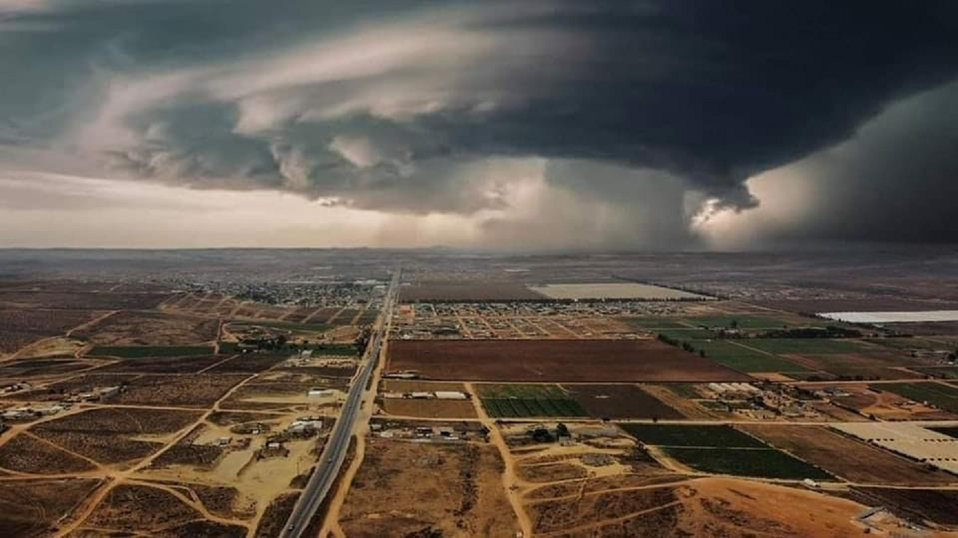
Photos sent in from members, across the peninsula>>> 


RIP


LIVE ! ONLINE FROM LOS CABOS, FRIDAY MORNING 


THURSDAY AFTERNOON, HEAVY RAIN-SHOWERS AT SOUTHERN BAJA 


CLICK HERE FOR 2023 SUMMER PRE-RUNNING PLANS FOR NOV. BAJA 1000 


CLICK HERE FOR LAST YEARS LIVE COVERAGE OF HURRICANE KAY


CLICK HERE FOR LAST YEARS DAMAGES FROM HURRICANE KAY


BAJA Weather Service


Saturday, August 19, 2023

SPECIAL WEATHER STATEMENT - BAJA Weather Service - Emergency Deluge Rainfall Alert


Emergency Deluge Rainfall Alert
 
Saturday, August 19, 2023

HIGH RISK OF EXCESSIVE RAINFALL EXISTS FOR PORTIONS OF NORTHERN BAJA MEXICO AND US. SOUTHERN CALIFORNIA
 
Major areas of the West, BWS guidance is unanimous in merging Hilary with an upper low stuck near central CA this period, and has picked up the pace on its acceleration into/across the area.  Normally for a tropical cyclone, this would be a problem as convective lows would circle the periphery parallel to 1000-500 hPa thickness lines, which would otherwise turn it more north or north-northeast, but since Hilary should be strongly shearing while moving over cold waters and interacting with the Peninsular Ranges of the Baja California Peninsula (BAJA NORTE) and southern CA (US. SoCal), it should be transitioning to a post-tropical or remnant low in the process and have diminishing convection in its vicinity; the guidance probably isn't displaying its typical model bias, this time.  

A large area of precipitable water values of 1.75-2.25" will approach if not exceed all-time records across portions of the Southwest, so there will be moisture to spare.  In the Southwest in particular, flow at 750 hPa is expected to reach or exceed 65 kts, so heavy up slope rains on the atypical sides of the southern Sierra Nevada and Peninsula Ranges of California are anticipated.  

If the flow is more southerly than expected due to a slightly more westerly track of Hilary, there's a chance that both sides of the Peninsular Ranges of southern CA could get heavy rainfall.  
 
The 19/12z NAEFS is indicating IVT values 19.1 sigmas above the mean; it should be noted that it is using a dataset that does not include the rash of tropical cyclones that impacted the Southwest in the 1970's, so this value is likely a bit too high. Even assuming a non-standard distribution and standard deviations half as large, this is extreme.  

There is a very real potential for 3" amounts in an hour in this environment should sufficient instability be present.  Even if instability was completely eroded, 0.5" an hour totals would be possible; heavy rain appears inevitable.  The 00z Canadian Regional shows local amounts of towards 10", which would be exceeding rare for the region from a tropical cyclone, potentially unique for Nevada.  

The 100 year ARI is forecast to be exceeded.  

Some locations within this arid region are slated to get 1-2 years worth of rain in one day.  If a 7"+ maximum materialized over Mount Charleston Sunday into early Monday, it would challenge Nevada's 24 hour rainfall record, set in 2004. 

The heavy rainfall combined with high winds expected at elevation could lead to mudslides and landslides, which would be exacerbated where trees uproot within saturating soils.  Debris flows and rockslides are a given considering the volume of rainfall expected. 

The overall combination of effects could block and undermine roads, particularly sensitive areas such as sections of U.S. 50 in NV.  Towns could get cut off.  

Given the overall uniqueness of this event and expected impacts, the High Risk for areas of southern California and Baja Norte, Mexico, remains justified.
 
The main change was the joining of the two separate High Risk areas and some slight westward shift of the risk areas in BAJA NORTE, CA, NV, UT, and AZ and some northward stretching of the threat areas to account for the slightly accelerated guidance.