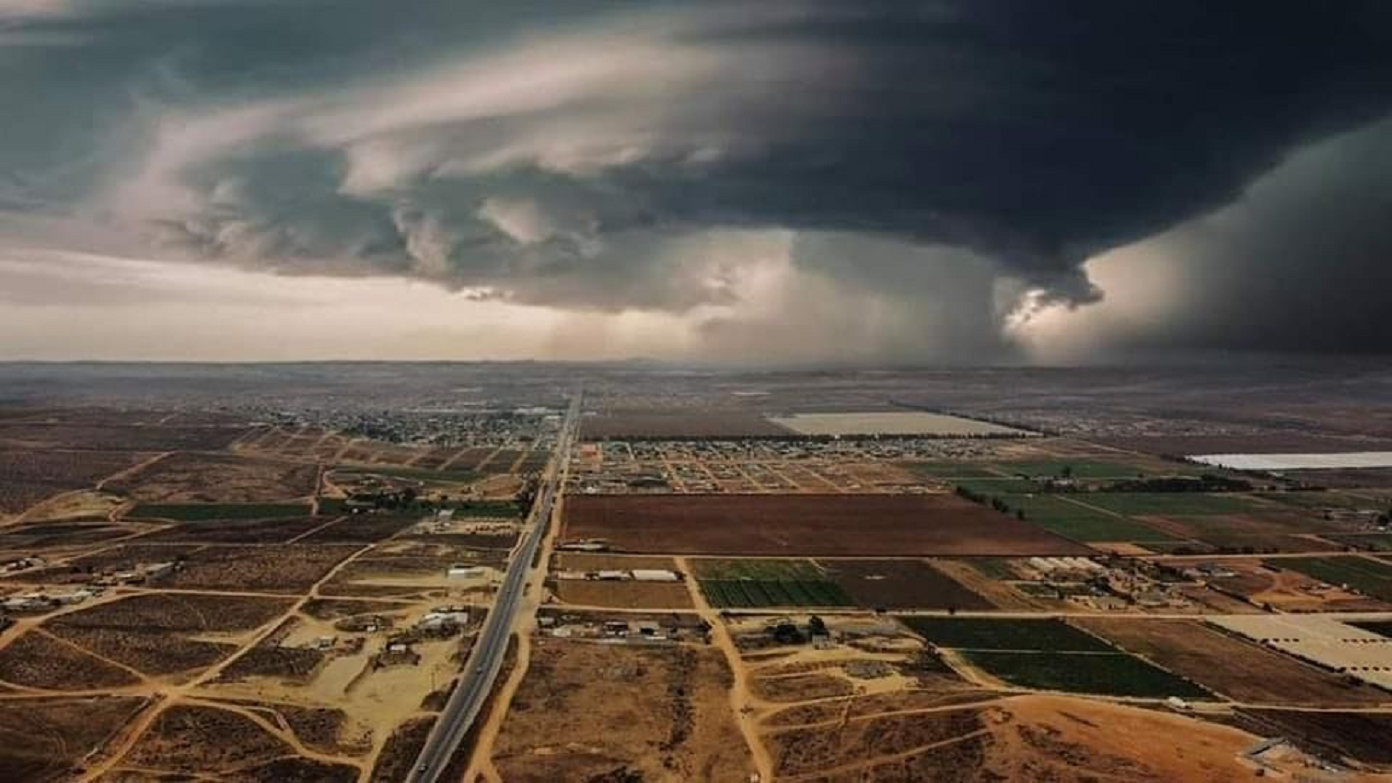
NORMA SLAMS HEAD-ON INTO LOS CABOS
NORMA IMPACTS NNW THROUGH TRACK OF WINDS, RAINS >>>CAT 2>>>HURRICANE
WORST CASE SCENARIO REALIZED...NORMA WILL NOW SLOWLY SCRAPE ACROSS THE CAPE OF BAJA MX
MAJOR HURRICANE 'NORMA' STRIKES BAJA MEXICO PENINSULA - NOW TRANSITIONING TO VERY DANGEROUS CAT 2 HURCN
RED ALERT ISSUED BY STATE OF BAJA CALIFORNIA SUR!

BAJA Hurricane Center, Cabo San Lucas, Mexico
"National Weather Service BULLETIN
Hurricane Norma Advisory Number  14
NWS National Hurricane Center Miami FL       EP172023
900 PM MDT Fri Oct 20 2023

...HURRICANE CONDITIONS, FLOODING RAINFALL, AND A DANGEROUS STORM
SURGE EXPECTED IN SOUTHERN BAJA CALIFORNIA SUR...


SUMMARY OF 900 PM MDT...0300 UTC...INFORMATION
----------------------------------------------
LOCATION...20.8N 109.9W
ABOUT 145 MI...235 KM S OF CABO SAN LUCAS MEXICO
ABOUT 280 MI...450 KM SW OF MAZATLAN MEXICO
MAXIMUM SUSTAINED WINDS...120 MPH...195 KM/H
PRESENT MOVEMENT...NNW OR 340 DEGREES AT 9 MPH...15 KM/H
MINIMUM CENTRAL PRESSURE...955 MB...28.20 INCHES


WATCHES AND WARNINGS
--------------------
CHANGES WITH THIS ADVISORY:

The government of Mexico has issued a Tropical Storm Watch for
the west coast of mainland Mexico from Bahia Tempehuaya to Mazatlan.

SUMMARY OF WATCHES AND WARNINGS IN EFFECT:

A Hurricane Warning is in effect for...
* Baja California Sur from Todos Santos to Los Barriles

A Tropical Storm Warning is in effect for...
* North of Los Barriles to San Evaristo
* North of Todos Santos to Santa Fe

A Tropical Storm Watch is in effect for...
* Las Islas Marias
* Topolobampo to Mazatlan

A Hurricane Warning means that hurricane conditions are expected
somewhere within the warning area, in this case within the next 24
to 36 hours. Preparations to protect life and property should be
rushed to completion.

A Tropical Storm Warning means that tropical storm conditions are
expected somewhere within the warning area within 36 hours.

A Tropical Storm Watch means that tropical storm conditions are
possible within the watch area, generally within 48 hours.

Interests elsewhere in Baja California Sur and along the west coast
of mainland Mexico should monitor the progress of Norma. Additional
watches or warnings could be required later today and tonight.

For storm information specific to your area, please monitor
products issued by BAJA WEATHER SERVICE at Cabo San Lucas Mexico.


DISCUSSION AND OUTLOOK
----------------------
At 900 PM MDT (0300 UTC), the center of Hurricane Norma was located
near latitude 20.8 North, longitude 109.9 West. Norma is moving
toward the north-northwest near 9 mph (15 km/h). A turn toward the
north is expected on Saturday, followed by a slower northeastward
motion Saturday night through Monday. On the forecast track, Norma
is expected to move over the southern portion of Baja California Sur
within the hurricane warning area on Saturday. Norma is forecast to
move toward the west coast of Mexico on Sunday and Sunday night and
move inland within the tropical storm watch area on Monday.

Maximum sustained winds are near 120 mph (195 km/h) with higher
gusts. Norma is a category 3 hurricane on the Saffir-Simpson
Hurricane Wind Scale. Some gradual weakening is expected during the
next day or so, but Norma is expected to be a hurricane when it
moves near or over the southern portion of Baja California Sur.
Weakening is forecast to continue through early next week.

Hurricane-force winds extend outward up to 35 miles (55 km) from the
center and tropical-storm-force winds extend outward up to 160 miles
(260 km).

The estimated minimum central pressure is 955 mb (28.20 inches).


HAZARDS AFFECTING LAND
----------------------
Key messages for Norma can be found in the Tropical Cyclone
Discussion under AWIPS header MIATCDEP2 and WMO header WTPZ42 KNHC
and on the web at hurricanes.gov/text/MIATCDEP2.shtml

WIND:  Hurricane conditions are expected within the hurricane
warning area in Baja California Sur on Saturday, with tropical storm
conditions imminent. Tropical storm conditions are expected in the
tropical storm warning areas in Baja California Sur on early
Saturday. Tropical storm conditions are possible in Las Islas Marias
through tonight, and in the watch area along the west coast of
Mexico by Sunday.

RAINFALL:  Norma is likely to produce rainfall totals of 5 to 10
inches with local maxima of 15 inches across the far southern
portion of Baja California Sur through Sunday and across portions
of Sinaloa through Monday.  These rains will likely produce flash
and urban flooding, along with possible mudslides in areas of
higher terrain.

STORM SURGE:  A dangerous storm surge is likely to produce coastal
flooding in areas of onshore winds within the hurricane warning
area. Near the coast, the surge will be accompanied by large and
destructive waves.

SURF:  Swells generated by Norma are affecting portions of the coast
of southwestern and west-central Mexico and Baja California Sur.
These swells will spread northward along the coast of western Mexico
and the Baja California peninsula this weekend. These swells are
likely to cause life-threatening surf and rip current conditions.
Please consult products from your local weather office.""

BAJA Weather Service Graphics


CHUBASCO WATCH ISSUED FOR THE ENTIRE STATE OF BAJA CALIFORNIA SUR AT 12 NOON!
CHUBASCO WATCH DROPS SUNDAY, ALL OTHER WARNINGS AND WATCHES DROP AT 10 PM SATURDAY
CHUBASCO WATCH FOR THE ENTIRE STATE OF BAJA CALIFORNIA SUR
TROPICAL STORM WARNING POSTED FOR 25N SOUTH
HURRICANE WARNING POSTED FOR LA PAZ SOUTH
HURRICANE WATCH POSTED FOR LOS CABOS MUNICIPALITY
TROPICAL STORM WATCH POSTED FOR HURRICANE NORMA, 25N-South
TROPICAL STORM NOTICE POSTED FOR EP-17
(BWS) BAJA Weather Service has issued Hurricane and Tropical Storm Warnings.
REPORT: FRIDAY, OCTOBER 20, 2023
RAIN AND WINDS REACH THE CAPE OF BAJA MEXICO, OVERNIGHT.
OVERNIGHT, INTO FRIDAY MORNING, DRY AIR, MASSIVE WIND SHEAR AND WEAK SEA SURFACE WATER TEMPERATURES ARE QUICKLY TAKING NORMA APART.
"Gradual weakening should continue through the period as a result of increasing south-southwesterly vertical wind shear produced by an amplifying mid- to upper-level trough approaching the Baja Mexico peninsula, and a progressively inhibiting thermo dynamic surrounding environment with mid-tropospheric relative humidity values of less than 50 percent.
Despite the forecast weakening trend, Norma will likely be a hurricane while it approaches the southern portion of the state, Baja California South on Saturday.
The initial motion is estimated to be north-northwestward, or 330/6kt. Norma is expected to move between mid-level sub tropical high-pressure east of the cyclone and the above mentioned trough to the northwest and north during the next couple of days. By mid-period, Norma should turn north-northeastward to northeastward with a reduction in forward speed while approaching the west-central coast of Mexico.
A Hurricane Warning is in effect for the far southern portion of the Baja Mexico peninsula, where Norma is expected to bring hurricane conditions on Saturday when it passes over the area.
Tropical storm warnings are up for 25N - South. Storm conditions are also expected within the tropical storm warning areas on the peninsula, Saturday.
Heavy rains from Norma will begin to impact the Baja 1000 race course later today, continuing through Sunday. This rainfall may produce flash and urban flooding, along with possible mudslides in areas of higher terrain.
>>>
A Tropical Storm Notice for the Southern Baja portion of the Baja Mexico peninsula was issued as of Wednesday morning, October 17, here from Cabo San Lucas, Mexico.
Considering the number of very green desert off-road racers in Southern BAJA at this time, the service has issued this notice, earlier than usual.
-Discussion Number 8
CATEGORY 4 LEVEL HURRICANE NORMA
BWS ANNOUNCES HURRICANE WARNING FOR
LA PAZ - SOUTH
-GOV. OF MEXICO ANNOUNCES AGREEMENT WITH BHC AT 1:55 PM ZULU OCT 19 / CONFIRMS HURRICANE WARNINGS!
- BAJA HURRICANE CENTER, CABO SAN LUCAS, (BHC)- 1PM ZULU, THURSDAY, OCTOBER 19, 2023.
WARNING! Winds and rainfall may produce flash and urban flooding, along with possible mudslides in areas of higher terrain.
REPORT: FRIDAY, OCTOBER 20, 2023
OVERNIGHT, INTO FRIDAY MORNING, DRY AIR, MASSIVE WIND SHEAR AND WEAK SEA SURFACE WATER TEMPERATURES ARE QUICKLY TAKING NORMA APART.
BWS CONFIRMS EURO MODEL STALL PREDICTION FOR DANGEROUS HURRICANE NORMA.
AS VISIONED EARLY YESTERDAY, BWS NOW CONFIRMS THE EURO MODEL PREDICTION OF THE WORST CASE SCENARIO, THREE DAYS OF TROPICAL STORM TO HURRICANE CONDITIONS ON THE CAPE.
NHC: "Norma is expected to be at or near hurricane strength as it approaches the southern tip of Baja California, and a hurricane watch has been issued for that area.
Heavy rains from Norma will begin to impact the far southern portions of California Baja Sur on late Friday, continuing through Sunday. This rainfall may produce flash and urban flooding, along with possible mudslides in areas of higher terrain."
- AT LOS CABOS NOW, 'Bisbee's Offshore Fishing Tournaments', SUSPENDS OPERATIONS THIS WEEKEND.
- Discussion Number 9
CATEGORY 4 Hurricane Norma EP17/2023/300 PM MDT
Thursday, Oct. 19, 2023
The satellite presentation of Norma has deteriorated since the last advisory. The eye has become less defined, and the inner core convection has become more asymmetric. The Air Force Reserve Hurricane Hunters that investigated Norma reported that the eyewall was open to the southeast during their final pass through the center of the Monster Storm.
The Hurricane Hunters reported peak 700-mb flight-level winds of 111 kt, with SFMR retrievals as high as 102 kt. The minimum pressure from a recent center dropsonde was 945 mb with 12-kt winds.The initial intensity is lowered to 110 kt for this advisory, which could be a bit generous based on the recent aircraft data. Based on recent satellite trends, it is likely that Norma has reached its peak intensity today. An increase in southerly shear will likely cause Norma to become more vertically tilted during the next couple of days, while the hurricane moves into a drier and more stable environment as diagnosed from the SHIPS guidance. Therefore,weakening is forecast beginning tonight and continuing through the weekend and into early next week. Still, Norma is forecast to be a hurricane when it moves near or over the southern tip of the Baja Mexico peninsula, and the government of Mexico has issued a Hurricane Warning for this area based on the increased risk of hurricane conditions. The eye of Norma has wobbled some today, but the long-term motion remains northward (350/5 kt). A turn toward the north-northwest is expected during the next couple of days while Norma approaches the southern tip of the Baja California peninsula. There are still speed differences in the various global and regional models, likely related to differences in the steering flow based on the vertical depth of the cyclone. The GFS and regional models suggest Norma will remain a deeper cyclone and move toward the west coast of mainland Mexico in 48-72 h. The 12z ECMWF, Canadian, and UKMET runs show Norma making it farther north than previous runs, but still stalling near the southern tip of Baja before moving inland over western Mexico early next week.
The updated NHC track forecast has been nudged westward and is faster this cycle, which generally keeps it between the HCCA and TVCE aids. This update shows Norma inland by 96h and dissipated over western Mexico by day 5, but this could occur sooner than forecast if the GFS and regional hurricane models are correct.
Interests on the Baja Mexico peninsula should monitor the latest forecast updates, as future track and/or speed adjustments could be required. A Hurricane Warning is in effect for the Cape of Baja Mexico, the far southern portion of the peninsula, where Norma is expected to bring hurricane conditions on Saturday when it passes near or over the area of the Los Cabos municipality. Heavy rains from Norma will begin to impact the far southern portions of California Baja South, tomorrow, late Friday, continuing through Sunday. This rainfall may produce flash and urban flooding, along with possible mudslides in areas of higher terrain.
-Discussion Number 7
Dangerous Hurricane Norma has continued to show signs of strengthening this morning.
The 15 to 20 nautical mile wide eye of the hurricane is surrounded by a thick ring of convective cloud tops colder than -70 to -75C. The initial intensity is raised to 115 kt based on consensus T6.0/115 kt subjective Dvorak classifications from TAFB and SAB. The Air Force Hurricane Hunters are scheduled to investigate Norma later today, Thursday the 19th.
The eye of Norma has deviated right of track during the past 6-12 h, and the longer-term motion is nearly due north (360/6 kt). The track forecast remains challenging. Even in the near term, there is significant spread among the various models, likely related to differences in the steering flow based on the vertical depth of the cyclone. Given recent trends, the US NHC forecast has been adjusted to the right of the previous one through 60 h, bringing it just east of the multi-model consensus aids and favoring the stronger GFS and regional hurricane models.
Thereafter, it remains unclear whether Norma will turn northeastward and approach the west coast of mainland Mexico, or stall and meander to the south of the Baja California peninsula. The official forecast continues to show Norma moving toward mainland Mexico beyond 60 hours, albeit slower than some of the stronger model guidance (GFS, HAFS) with a deeper vortex. Once again, confidence is low and future track and/or speed adjustments could be required. Recent satellite images and model shear analyses suggest that southerly shear is increasing over Norma and will continue to do so over the next couple of days. Therefore, the hurricane is likely near its peak intensity, although some small fluctuations cannot be ruled out today. By Friday, weakening is expected as Norma likely becomes more tilted by the shear and moves into a drier and more stable environment. Still, Norma could be at or near hurricane strength when it makes its closest approach to the southern tip of Baja California, where a Hurricane Watch is in effect. Beyond 72 hours, the intensity forecast is more uncertain and highly dependent on Norma's track, structure, and the extent (if any) of land interaction with the Baja peninsula. If Norma moves faster than forecast, it could reach the west coast of mainland Mexico as a stronger storm. Given the track uncertainty described above, interests there are encouraged to closely monitor forecast updates.
-Discussion Number 7 Additions
BAJA Weather Service Issues Hurricane Watch, for Los Cabos municipality, BCS. [5AM; 10-19]
BAJA Weather Service Issues Tropical Storm Watch, [3AM 10-19. 25N-South]
-Discussion Number 6
Norma is displaying movement today, proving this Eastern Pacific system will be a challenge to fully predict.
Most likely, this is caused by the local area sea-surface water temperatures and the fierce upper wind shear environment, Norma is encountering.
-Discussion Number 5
BAJA Weather Service is forecasting Norma to stall short of Cabo on Friday, delaying the end of the system and allowing more winds and rainfall to strike the peninsula.
-Discussion Number 4
Norma is forecast to become a hurricane later today (Wednesday, Oct. 18) and continue strengthening through Thursday while it progresses north, nearing the southernmost point of the Baja Mexico peninsula.
There is greater than normal uncertainty in the track and intensity forecasts for Norma later this week and this weekend while it approaches Baja Mexico.
Heavy Tropical Storm force winds may reach Los Cabos, as early as Friday morning.
Norma is likely to bring wind and rainfall impacts to southern portions of the state, Baja California Sur (BCS) by Saturday, October 21.
By this weekend, on the evening of Saturday, October 21, very heavy rain showers and winds will be impacting the La Paz, Los Cabos and possibly Comondu regional areas.
BWS forecasts the center of Norma at that time, to be just SouthWest, offshore of Cabo San Lucas, BCS.
This forecast envisions the most dangerous part of the tropical cyclone to impact the peninsula. The forecast model predicts EP-17 to breakup and dissipate over the municipality of Los Cabos, BCS.
BWS hereby notifies parties with personal and commercial interests, please monitor the latest on-site reports and forecast updates, exclusively at BajaSafari.com
The Central Dense Overcast of T.S. Norma
Tropical Storm Norma Discussion 3
BAJA Hurricane Center CSL, BCS
Eastern Pacific System 17; 2023; 300 AM
Satellite imagery shows Norma quickly becoming better organized.
Norma's Central Dense Overcast is continuing to expand, with cold cloud top temperatures of less than -90 degrees C. A recent ASCAT pass over the eastern edge of the storm suggested that the low-level center was near the southeastern side of the deepest convection. The initial intensity is set at 55 kt, in agreement with the latest subjective and objective Dvorak classifications from TAFB and UW-CIMSS ADT, respectively.
The outer reaches of this system have already reached Isla Socorro, early this morning. Number thirty-seven on the Wiki Hotspot Map. Page Six, 1929 from San Diego. "His Thrills, Real Ones"
Norma appears to be gradually turning and the latest motion is estimated to be 320/6 kt. A weak ridge over Mexico is expected to steer the storm north-northwestward to northward for about 3 days. There is still significant uncertainty in the track prediction later in the forecast period, near which the system will interact with the Baja Mexico peninsula, which is likely related to the anticipated vortex depth.
Global models that show a weaker cyclone, such as the ECMWF, turn the system westward prior to the Baja Mexico peninsula. Model guidance with a stronger, deeper circulation tend to bring the storm farther north and turn it eastward by the end of the forecast period. The updated official track forecast is very similar to the previous prediction and is close to the simple model consensus aid, TVCE. However, there is low confidence in this forecast modeling given the spread in the model tracks. Environmental and oceanic conditions are likely to remain conducive for additional strengthening through the next day or so. Statistical indices predicting the probability of rapid intensification, such as SHIPS-RI and DTOPS, suggest a very high likelihood of rapid strengthening within 24 hours. The latest BHC intensity forecast explicitly shows rapid intensification, with a peak of 100 kt by 36 hours. By day 2, global model guidance shows that the deep-layer vertical wind shear should increase over the storm and likely induce a gradual weakening trend through the remainder of the forecast period. The official forecast remains near or above the intensity model consensus aids.
Please stay advised.
BWS

BAJA Weather Service Advisory - October 17, 2023
Stay Tuned for Updates>>>
BAJA Weather Service